country/areas included
iron ore mines tracked
plant owners
tonnes annual production capacity
Overview
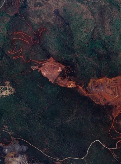
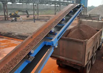
Global Energy Monitor’s Global Iron Ore Mines Tracker (GIOMT) shows geographic concentrations of iron ore mining capacity that shape downstream iron and steel production and influence the global transition to green steel.
The GIOMT maps asset-level ownership, development and operating status, design capacity, and annual production since 2022 for each mine. It reveals a highly concentrated global supply dominated by Australia, Brazil, and China. Because iron ore mining is a fundamental element of the steelmaking supply chain, upstream investment decisions tracked in the GIOMT will shape whether future supply aligns with net-zero steel transition pathways.
Each iron ore mine varies in terms of size and infrastructure. The majority of iron ore mine assets are reported individually, but in other scenarios several mines may be reported together under a larger mining complex when more granular data is unavailable. The GIOMT typically does not capture historic data on mining assets retired prior to 2023. Each iron ore mine is linked to its own separate factsheet on GEM.wiki, which provides additional details.
Australia dominates global iron ore supply, accounting for 32% of global operating capacity.
Australia, Brazil, Russia, and China hold the largest iron ore reserves and resources, together accounting for 54% of global long-term supply potential.
What's inside?
Methodology
Global Energy Monitor’s Global Iron Ore Mines Tracker uses a two-level system for organizing information, consisting of both a database and wiki pages with further information. The database tracks iron mines and includes information such as mine owner and parent company, mine operating status, design capacity, annual production since 2022, and location. A wiki page for each plant is created within GEM.wiki, and contains footnoted information.
A preliminary list of iron ore mines in each country was gathered from public and private data sources including U.S. Geological Survey Mineral Yearbooks and Mineral Resources Data System, Brazil Mineral Magazine, Brazilian Mineral Yearbook, National Geological Archives of China, and Indian Bureau of Mines, as well as various company and government sources. Prior work by the Climate Trace coalition was also included in the preliminary mine list, and incorporated assets from Mining Data Online and the website Mining Technology in addition to USGS Mineral Yearbooks. Data for proposed iron ore mines was gathered from company announcements, press releases, and government permits, and includes global coverage of iron ore mines proposed as of July 1, 2025. The data was then vetted against additional sources of information, listed below.
Iron ore mine data is updated and maintained through five main sources:
- Corporate reports and data sources from iron ore mine owner and parent companies
- Government data on individual iron ore mines
- Reports by national and regional iron mining and steel industry groups
- News and media reports
- Reports from mining technology manufacturers
Where possible, iron ore mine data is circulated for review to researchers familiar with local conditions and languages.
For each iron ore mine, a wiki page is created on Global Energy Monitor’s GEM.wiki. Wiki pages provide a repository for mine details including mine owner, parent company, mine status, design capacity and actual production, and location (coordinates and map), as well as additional in-depth information that may include mine background, financing, environmental impacts, end users, public opposition, aerial photographs, videos, and links to plant environmental permits. Under standard wiki convention, all information is linked to a published reference, such as a news article, company or government report, or a regulatory permit. In order to ensure data integrity in the open-access wiki environment, Global Energy Monitor researchers review all edits of project wiki pages.
Design capacity includes the permitted or company-declared amount of iron ore the mine can extract per year in thousands of metric tonnes per annum. Run-of-mine is recorded where available, otherwise capacities of final products such as lump and fines, concentrate, and pellets are included as capacity. Production is actual tonnes of run-of-mine, when available, or iron ore product per annum produced by the mine. Due to the nature of mine exploration and planning, actual production can exceed design capacity when reserves and/or resources prove to be larger than initially identified or a mine extracts beyond its intended capacity.
The tracker collects data on iron reserves and resources at each operation and project in thousands of metric tonnes following JORC reporting standards as closely as possible. The Total Reserve figure includes both proven and probable reserves. The Total Resource figure includes measured, indicated, and inferred resources. A subset of these (e.g. only proven reserves, or only measured and indicated resources) may be recorded when available data is incomplete. Resources are reported inclusive of reserves as much as possible.
Proposed: A mine is considered “proposed” if at any stage prior to that (announced, leasing, permitting, construction, etc.)
Operating: A mine is considered “operating” if iron is coming out of the ground for commercial purposes (including “test operations” in China).
Shelved: A proposed mine is considered “shelved” if there are no updates or evidence the project is proceeding after 2 years.
Retired: A mine is considered “retired” if it has been formally closed or is non-operational for more than one year with no indicated plans to restart operations.
Mothballed: A mine is considered “mothballed” if it is not operational for more than 6 months but has not been formally closed or retired. This includes mines on “care and maintenance”. We consider them “operating” mines if the “care and maintenance” was temporary, and mothballed if it’s longer than 6 months.
Cancelled: A proposed mine is “cancelled” if there are no updates or evidence the project is proceeding after 3 years, or a formal announcement is made from corporate or government authorities.
To allow easy public access to the results, Global Energy Monitor worked with Earth Genome to develop a map-based and table-based interface. In the case of exact coordinates, locations have been visually determined using Google Maps, Google Earth, Planet Labs, or Wikimapia. For proposed projects, exact locations, if available, are from permit applications or other company documentation. If the location of a plant or proposal is not known, GEM identifies the most approximate location.
Frequently Asked Questions
The colors indicate the status category:
Proposed: A mine is considered “proposed” if at any stage prior to that (announced, leasing, permitting, construction, etc.)
Operating: A mine is considered “operating” if iron is coming out of the ground for commercial purposes (including “test operations” in China).
Shelved: A proposed mine is considered “shelved” if there are no updates or evidence the project is proceeding after 2 years.
Retired: A mine is considered “retired” if it has been formally closed or is non-operational for more than one year with no indicated plans to restart operations.
Mothballed: A mine is considered “mothballed” if it is not operational for more than 6 months but has not been formally closed or retired. This includes mines on “care and maintenance”. We consider them “operating” mines if the “care and maintenance” was temporary, and mothballed if it’s longer than 6 months.
Cancelled: A proposed mine is “cancelled” if there are no updates or evidence the project is proceeding after 3 years, or a formal announcement is made from corporate or government authorities.
Each iron ore mine location is marked “exact” or “approximate.” In the case of exact coordinates, locations have been visually determined using Google Maps, Google Earth, or Wikimapia (existing projects). For proposed projects, exact locations, if available, are from permit applications or other company documentation.
If an iron ore mine is still in the proposal phase, prior to construction and extraction, there may be no sign of activity. In other cases, only approximate location information could be found. Underground mines may show limited activity above ground and the location may point to a ventilation shaft or building where the underground mine is accessed. Finally, satellite photos in some geographies are updated infrequently, so recent activity is not shown.
To find out the coordinates of a location and whether a location is exact or approximate, click on the location dot, select the wiki page, and look under “Project Details.” Locations tend to be known with greater accuracy as mines move from early stages of development toward construction and operation.
Yes, click on “Table View” in the bottom banner of the map. Download the dataset here.
Capacity is the tonnes of iron ore per annum that a mine is designed to extract. Production is actual tonnes of iron ore extracted at a mine in a given year.
Run of mine is recorded when available, otherwise capacities of saleable products such as lump and fines, concentrate, and pellets are recorded.
In some areas with limited data, there may be no official operation of a mine as confirmed by company or government reports, but potential unpermitted extraction has been indicated so the mine status is “unknown”. In other cases, the mine has operated in the past but available information is inconclusive on continued operation or confirmed mothballing or retirement of the mine.
The tracker collects data on iron ore reserves and resources at each operation and project in thousands of metric tonnes recorded as closely as possible to JORC standards. Resources are recorded inclusive of reserves. Resources and reserves in countries that follow other mineral reporting guidelines are mapped to JORC as closely as possible, following guidance laid out by CRIRSCO and the UN. In cases where mines are part of a hub or complex and resources and reserves are only found for the entire hub or complex, those totals are split evenly across the individual mines or pits that make up the hub or complex.
The tracker only includes mines that primarily extract iron ores like hematite, magnetite, goethite and siderite. Multi-metal mines where iron is not the primary product and mines that produce pig iron as a byproduct of titanium or vanadium mining and refining (for example from ilmenite ores) are not included.
At this time the tracker does not include details on the specific grades of iron ore mined at each project.
The GIOMT owner and parent data is integrated with GEM’s Global Energy Ownership Tracker (GEOT).
The GIOMT reports the first owner/operator of the plant in the “Owner” column and the ultimate parent companies along with their percent stake in the plant in the “Parent” column. Each owner can be found in GEM’s GEOT for more detailed information on the ownership “tree” in between the mine’s direct owners and the ultimate parent companies. If there is an owner or parent with no stake percentage listed, the exact percentage data has not been confirmed. If there is a parent missing, the GEOT has not yet been updated and will include this information shortly. If an owner is missing an “Owner GEM Entity ID”, the GEOT has not yet been updated and will include this information shortly.
Please fill out an error report here.
The tracker was designed and produced by Global Energy Monitor. To the extent possible, the information in the tracker has been verified by researchers familiar with particular countries. The following people participated in asset-level research: Henna Khadeeja (Global Energy Monitor), Fanwei Liu (Global Energy Monitor), Rolando Almada (Global Energy Monitor), Gregor Clark (Global Energy Monitor), Jessie Zhi (Global Energy Monitor), Natalia Fretz (Global Energy Monitor), Zhanaiym Kozybay (Global Energy Monitor), Ziwei Zhang (Global Energy Monitor), Charmaine Dalisay (Global Energy Monitor), and Charlene Hou, Marie Armbruster, and Meet Muchala (formerly Global Energy Monitor). The project is managed by Henna Khadeeja and Caitlin Swalec, within GEM’s Heavy Industry Program, with support from Louisa Plotnick and Ted Nace. Web/GIS programming was done by Taylor Higgins and Wiki page creation by Hannah Howell Parent company information was created by GEM’s Global Energy Ownership Tracker, managed by Anna Mowat and researched by Gabe Louis and Sarah Kapp.
Please refer to the Download Data section for citation guidance.
Contact
For questions about the Global Iron Ore Mines Tracker, contact Caitlin Swalec: